|
Suburb & Date
|
Description
|
Comments
|
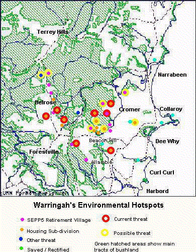
Allambie - June 1999 |
Ardel residential sub-division. 32 dwellings |
Rare Duffys Forest flora. Water quality issues - rare fish under threat. |
Allambie - mid 1990s |
SEPP5 retirement villages along Allambie Rd |
|
Allambie - early 1990s |
SEPP5 retirement village, Aquatic Dr, Allambie |
Manly Dam catchment |
Allambie - 1997 |
SEPP5 retirement villages along Allambie Rd |
|
Beacon Hill - 1992 |
REP21 Landcom subdivision at Red Hill. 30 Ha |
Forced on Council by State Government in 1988. Stage 3/4 revised to
preserve some bushland. |
Beacon Hill - 1997 |
REP21 Norbel subdivision at Red Hill. 5 Ha |
" |
Beacon Hill - 1997 |
Brooker Av subdivision 3Ha |
Rezoned for subdivision due to SEPP5 issues |
Beacon Hill - 1999 |
Brooker Av 10Ha of non-urban land sold. Possible SEPP5 application. |
Last untouched headwaters of South Creek. Prominent rock platform with
rare flora. |
Beacon Hill - 1999 |
Willandra Rd - Several owners of non-urban land have raised the issue
of subdivision |
Some sensitive escarpments and important headwaters |
Beacon Hill - 1999 |
Catholic Church considering a major subdivision at Red Hill |
Church land includes the sensitive Wheeler Creek valley |
Beacon Hill - 1998 |
Land fill on north escarpment of Red Hill |
Huge quantities of land fill on a new access road and residential block.
Weeds and siltation concerns. |
Belrose - late 1980s |
SEPP5 Belrose Country Club - 10Ha of cleared land |
|
Belrose - late 1980s |
SEPP5 Glenaeon Retirement Village |
|
Belrose - late 1980s |
SEPP5 Wesley Retirement Village |
|
Belrose - 1998 |
Subdivision of former road corridor |
|
Belrose - 1998 |
Subdivision off Forest Way, opposite Ralston Av |
|
Belrose - 1998 |
Subdivision off Perentie Rd |
Potential for SEPP5 retirement village a factor in Council approval |
Belrose - 1999 |
Sale of land on Forest Way, opposite Bundaleer St |
Possible SEPP5 or subdivision |
Belrose - 1999 |
Sale of land zoned industrial on Forestway |
|
Brookvale - 1998 |
MLALC conservation agreement for escarpment |
+ |
Brookvale - 1998 |
Subdivision of former brickworks site |
|
Collaroy Plateau - 1997 |
Wars Veterans Home application to extend |
On hold? |
Cromer - early 1990s |
SEPP5 Willandra Village |
Steep block on the edge of South Creek. |
Cromer - 1998 |
SEPP5 Retirement village on former nursery site |
Bush on escarpment preserved |
Cromer - early 1990s |
SEPP5 Maybrook Manor |
Applied for extension |
Cromer - 1997 & current |
Possible SEPP5 on non-urban land at the end of Northcott Rd, Cromer
Heights |
"Cromer Highlands" abandoned after strong community protest. Possible
subdivision with top of block preserved. A nearby block is being advertised
as having SEPP5 potential. |
Cromer - 1998 |
REP21 Landcom subdivision at Cromer Rd |
Forced on Council by State Government |
Curl Curl - 1998 |
Greendale creek gross pollutant trap |
+ |
Dee Why - 1997 |
Dee Why Wetland project |
+Community restoration of a creek flowing into Dee Why Lagoon |
Dee Why - 1998 |
Proposals to rezone tennis courts and hotel |
|
Frenchs Forest |
Carnarvon Dr subdivision |
|
Long Reef - 1998 |
Wetlands created on Long Reef Golf Course |
+ |
Long Reef - 1980s |
Long Reef Aquatic Reserve |
+ |
Narrabeen - early 1990s |
Coastal Environment Centre |
+ |
Oxford Falls |
Church and school developments on non-urban land |
|
Oxford Heights - 1998 |
REP21 landcom subdivision |
Forced on Council by State Government |
| ?? |
|
|